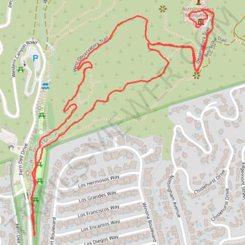
Griffith Observatory Loop via East and West Observatory Trails in Griffith Park
The Griffith Observatory Loop via the East and West Observatory Trails in Griffith Park offers hikers a rewarding experience with panoramic views of Los Angeles. Along the route, one can observe the iconic Griffith Observatory, the Hollywood Sign, and the expansive Los Angeles skyline. The trails also provide vistas of the San Gabriel Mountains and, on clear days, the Pacific Ocean. #Hiking #Mountain #Forest #Nature #Loop #Overlook
- Distance: 2.3 mi
- Elevation gain: 208 m
- Maximum elevation: 345 m
- Elevation loss: 208 m
- Minimum elevation: 179 m
- Moving time: 46 m 55 s
- Moving speed: 3.0 mph
- Maximum speed: 8.4 mph
- Total time: 46 m 55 s
- Global speed: 3.0 mph
Interactive trail map
Trail profile
- Distance: 2.3 mi
- Elevation gain: 208 m
- Maximum elevation: 345 m
- Elevation loss: 208 m
- Minimum elevation: 179 m
- Moving time: 46 m 55 s
- Moving speed: 3.0 mph
- Maximum speed: 8.4 mph
- Total time: 46 m 55 s
- Global speed: 3.0 mph
About this trail
Name: Griffith Observatory Loop via East and West Observatory Trails in Griffith Park trail, distance, elevation, map, profile, GPS track
Coordinates: 34.11102 -118.30718 34.11864 -118.29976
Other hiking, mountain biking, running and outdoor activity trails
Click on a trail to view its statistics, map and profile.