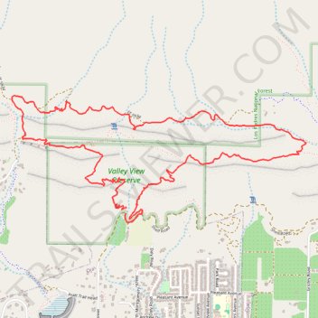
Valley View Preserve
- Distance: 5.2 mi
- Elevation gain: 517 m
- Maximum elevation: 555 m
- Elevation loss: 522 m
- Minimum elevation: 325 m
- Moving time: 1 h 57 m
- Moving speed: 2.6 mph
- Maximum speed: 4.8 mph
- Total time: 2 h 4 m
- Global speed: 2.5 mph
Interactive trail map
Trail profile
- Distance: 5.2 mi
- Elevation gain: 517 m
- Maximum elevation: 555 m
- Elevation loss: 522 m
- Minimum elevation: 325 m
- Moving time: 1 h 57 m
- Moving speed: 2.6 mph
- Maximum speed: 4.8 mph
- Total time: 2 h 4 m
- Global speed: 2.5 mph
About this trail
Name: Valley View Preserve trail, distance, elevation, map, profile, GPS track
Start: Fox Canyon Trail, Ojai, Ventura County, California, 93023, United States (34.46599 -119.24351)
End: Shelf Road, Ojai, Ventura County, California, 93023, United States (34.46560 -119.24357)
Coordinates: 34.46497 -119.25322 34.47384 -119.22829
Other hiking, mountain biking, running and outdoor activity trails
Click on a trail to view its statistics, map and profile.
Magic Mountain Loop via Foothill Trail and Cozy Del
United States > California > Ventura County
Distance: 3.2 mi • Elevation gain: 277 m • Maximum elevation: 598 m