Brixham Paignton Loop Hike
- Distance: 19.0 mi
- Elevation gain: 585 m
- Maximum elevation: 64 m
- Elevation loss: 583 m
- Minimum elevation: 0 m
- Moving time: 7 h 17 m
- Moving speed: 2.6 mph
- Maximum speed: 5.0 mph
- Total time: 7 h 46 m
- Global speed: 2.4 mph
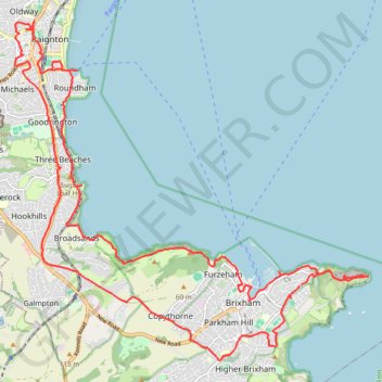
Interactive trail map
Trail profile
- Distance: 19.0 mi
- Elevation gain: 585 m
- Maximum elevation: 64 m
- Elevation loss: 583 m
- Minimum elevation: 0 m
- Moving time: 7 h 17 m
- Moving speed: 2.6 mph
- Maximum speed: 5.0 mph
- Total time: 7 h 46 m
- Global speed: 2.4 mph
About this trail
Name: Brixham Paignton Loop Hike trail, distance, elevation, map, profile, GPS track
Start: 69, Wall Park Road, Rea Hill, Brixham, Torbay, England, TQ5 9UL, United Kingdom (50.39822 -3.49951)
End: 69, Wall Park Road, Rea Hill, Brixham, Torbay, England, TQ5 9UL, United Kingdom (50.39782 -3.50002)
Coordinates: 50.38595 -3.57215 50.44048 -3.48284
Topography: Torbay topographic map, elevation, terrain
Other hiking, mountain biking, running and outdoor activity trails
Click on a trail to view its statistics, map and profile.
Galmpton Stoke Fleming
United Kingdom > England > Torbay > Galmpton
Distance: 18.7 mi • Elevation gain: 815 m • Maximum elevation: 188 m