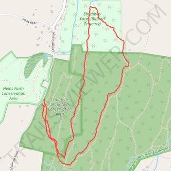
Leadmine Mountain Loop via Mountain Laurel and Cow Stile trails
- Distance: 3.3 mi
- Elevation gain: 94 m
- Maximum elevation: 286 m
- Elevation loss: 92 m
- Minimum elevation: 225 m
- Moving time: 1 h 30 m
- Moving speed: 2.2 mph
- Maximum speed: 7.6 mph
- Total time: 1 h 31 m
- Global speed: 2.2 mph
Interactive trail map
Trail profile
- Distance: 3.3 mi
- Elevation gain: 94 m
- Maximum elevation: 286 m
- Elevation loss: 92 m
- Minimum elevation: 225 m
- Moving time: 1 h 30 m
- Moving speed: 2.2 mph
- Maximum speed: 7.6 mph
- Total time: 1 h 31 m
- Global speed: 2.2 mph
About this trail
Name: Leadmine Mountain Loop via Mountain Laurel and Cow Stile trails trail, distance, elevation, map, profile, GPS track
Coordinates: 42.08805 -72.11333 42.10278 -72.10243