Thank you for supporting this site ❤️
Make a donation
Make a donation
Gear up for your next adventure:
As an Amazon Associate, this site earns from qualifying purchases at no extra cost to you.
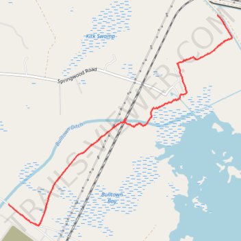
Palmetto Trail Lake Moultrie Passage
- Distance: 3.5 mi
- Elevation gain: 9 m
- Maximum elevation: 28 m
- Elevation loss: 5 m
- Minimum elevation: 22 m
- Moving time: 40 m 4 s
- Moving speed: 5.2 mph
- Maximum speed: 19.2 mph
- Total time: 47 m
- Global speed: 4.5 mph
Interactive trail map
Thank you for supporting this site ❤️
Make a donation
Make a donation
Gear up for your next adventure:
As an Amazon Associate, this site earns from qualifying purchases at no extra cost to you.
Trail profile
- Distance: 3.5 mi
- Elevation gain: 9 m
- Maximum elevation: 28 m
- Elevation loss: 5 m
- Minimum elevation: 22 m
- Moving time: 40 m 4 s
- Moving speed: 5.2 mph
- Maximum speed: 19.2 mph
- Total time: 47 m
- Global speed: 4.5 mph
Thank you for supporting this site ❤️
Make a donation
Make a donation
Gear up for your next adventure:
As an Amazon Associate, this site earns from qualifying purchases at no extra cost to you.
About this trail
Name: Palmetto Trail Lake Moultrie Passage trail, distance, elevation, map, profile, GPS track
End: Viper Road, Berkeley County, South Carolina, 29436, United States (33.38974 -80.11823)
Coordinates: 33.38707 -80.11823 33.41404 -80.08392
Thank you for supporting this site ❤️
Make a donation
Make a donation
Gear up for your next adventure:
As an Amazon Associate, this site earns from qualifying purchases at no extra cost to you.