Thank you for supporting this site ❤️
Make a donation
Make a donation
Gear up for your next adventure:
As an Amazon Associate, this site earns from qualifying purchases at no extra cost to you.
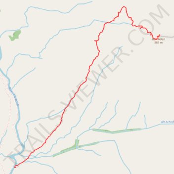
Ben Aden from the South - Uphill
- Distance: 1.9 mi
- Elevation gain: 851 m
- Maximum elevation: 876 m
- Elevation loss: 3 m
- Minimum elevation: 25 m
- Moving time: 1 h 41 m
- Moving speed: 1.1 mph
- Maximum speed: 3.2 mph
- Total time: 3 h 26 m
- Global speed: 0.5 mph
Interactive trail map
Thank you for supporting this site ❤️
Make a donation
Make a donation
Gear up for your next adventure:
As an Amazon Associate, this site earns from qualifying purchases at no extra cost to you.
Trail profile
- Distance: 1.9 mi
- Elevation gain: 851 m
- Maximum elevation: 876 m
- Elevation loss: 3 m
- Minimum elevation: 25 m
- Moving time: 1 h 41 m
- Moving speed: 1.1 mph
- Maximum speed: 3.2 mph
- Total time: 3 h 26 m
- Global speed: 0.5 mph
Thank you for supporting this site ❤️
Make a donation
Make a donation
Gear up for your next adventure:
As an Amazon Associate, this site earns from qualifying purchases at no extra cost to you.
About this trail
Name: Ben Aden from the South - Uphill trail, distance, elevation, map, profile, GPS track
Start: Highland, Scotland, United Kingdom (57.01986 -5.48509)
End: Coire na Leac, Highland, Scotland, United Kingdom (57.03085 -5.46331)
Coordinates: 57.01986 -5.48534 57.03315 -5.46329
Topography: Highland topographic map, elevation, terrain
Thank you for supporting this site ❤️
Make a donation
Make a donation
Gear up for your next adventure:
As an Amazon Associate, this site earns from qualifying purchases at no extra cost to you.