
Tanyard Creek Park Loop
The Tanyard Creek Park Loop offers a serene escape with its well-maintained paths that wind alongside a picturesque creek and through lush woodlands. Highlights of the route include a scenic waterfall and a charming wooden bridge, providing perfect spots for photographs and moments of reflection. Suitable for all skill levels, the trail combines natural beauty with accessibility, making it a delightful option for families and casual hikers alike. #Hiking #Park #Loop #Waterfall #Forest #Nature
- Distance: 1.9 mi
- Elevation gain: 59 m
- Maximum elevation: 326 m
- Elevation loss: 57 m
- Minimum elevation: 305 m
- Moving time: 50 m 53 s
- Moving speed: 2.2 mph
- Maximum speed: 3.5 mph
- Total time: 57 m 46 s
- Global speed: 2.0 mph
Interactive trail map
Trail profile
- Distance: 1.9 mi
- Elevation gain: 59 m
- Maximum elevation: 326 m
- Elevation loss: 57 m
- Minimum elevation: 305 m
- Moving time: 50 m 53 s
- Moving speed: 2.2 mph
- Maximum speed: 3.5 mph
- Total time: 57 m 46 s
- Global speed: 2.0 mph
About this trail
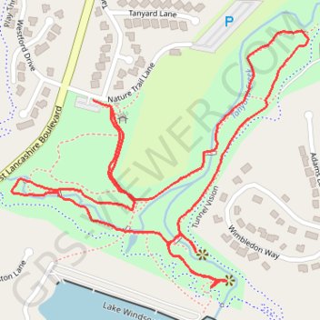
Name: Tanyard Creek Park Loop trail, distance, elevation, map, profile, GPS track
Start: Nature Trail Lane, Bella Vista, Benton County, Arkansas, 72714, United States (36.47179 -94.26099)
End: Nature Trail Lane, Bella Vista, Benton County, Arkansas, 72714, United States (36.47196 -94.26144)
Coordinates: 36.46818 -94.26348 36.47334 -94.25607