Make a donation
Gear up for your next adventure:
As an Amazon Associate, this site earns from qualifying purchases at no extra cost to you.
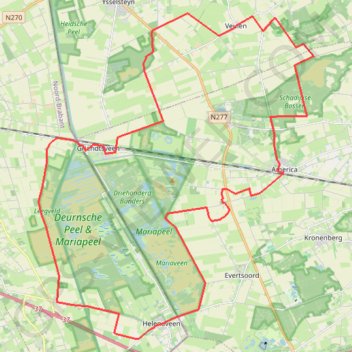
Meerdal-44-km-bij-america
- Distance: 27.4 mi
- Elevation gain: 56 m
- Maximum elevation: 35 m
- Elevation loss: 56 m
- Minimum elevation: 28 m
Interactive trail map
Make a donation
Gear up for your next adventure:
As an Amazon Associate, this site earns from qualifying purchases at no extra cost to you.
Trail profile
- Distance: 27.4 mi
- Elevation gain: 56 m
- Maximum elevation: 35 m
- Elevation loss: 56 m
- Minimum elevation: 28 m
Make a donation
Gear up for your next adventure:
As an Amazon Associate, this site earns from qualifying purchases at no extra cost to you.
About this trail
Name: Meerdal-44-km-bij-america trail, distance, elevation, map, profile, GPS track
Start: Lorbaan, America, Horst aan de Maas, Limburg, Netherlands, 5966 PG, Netherlands (51.45354 5.97276)
End: Lorbaan, America, Horst aan de Maas, Limburg, Netherlands, 5966 PG, Netherlands (51.45354 5.97276)
Coordinates: 51.38382 5.85601 51.48620 5.99468
Make a donation
Gear up for your next adventure:
As an Amazon Associate, this site earns from qualifying purchases at no extra cost to you.
Other hiking, mountain biking, running and outdoor activity trails
Click on a trail to view its statistics, map and profile.
Eurovelo 15 - Strasbourg Rotterdam
France > Grand Est > Bas-Rhin > Strasbourg
Distance: 554.1 mi • Elevation gain: 2,104 m • Maximum elevation: 146 m
28-01-2024-gravel met Marion
Netherlands > Limburg > Oostrum
Distance: 25.4 mi • Elevation gain: 78 m • Maximum elevation: 30 m