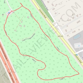
Emily Bayless Graham Park Loop
- Distance: 1.1 mi
- Elevation gain: 9 m
- Maximum elevation: 92 m
- Elevation loss: 9 m
- Minimum elevation: 85 m
- Moving time: 24 m 26 s
- Moving speed: 2.7 mph
- Maximum speed: 3.5 mph
- Total time: 26 m 22 s
- Global speed: 2.5 mph
Interactive trail map
Trail profile
- Distance: 1.1 mi
- Elevation gain: 9 m
- Maximum elevation: 92 m
- Elevation loss: 9 m
- Minimum elevation: 85 m
- Moving time: 24 m 26 s
- Moving speed: 2.7 mph
- Maximum speed: 3.5 mph
- Total time: 26 m 22 s
- Global speed: 2.5 mph
About this trail
Name: Emily Bayless Graham Park Loop trail, distance, elevation, map, profile, GPS track
End: Sensory Trail, Emmorton, Harford County, Maryland, 21015, United States (39.49106 -76.32361)
Coordinates: 39.48661 -76.32427 39.49156 -76.31801