Cougar trails
- Distance: 2.7 mi
- Elevation gain: 57 m
- Maximum elevation: 81 m
- Elevation loss: 53 m
- Minimum elevation: 35 m
- Moving time: 1 h 3 m
- Moving speed: 2.6 mph
- Maximum speed: 6.2 mph
- Total time: 1 h 12 m
- Global speed: 2.3 mph
Interactive trail map
Trail profile
- Distance: 2.7 mi
- Elevation gain: 57 m
- Maximum elevation: 81 m
- Elevation loss: 53 m
- Minimum elevation: 35 m
- Moving time: 1 h 3 m
- Moving speed: 2.6 mph
- Maximum speed: 6.2 mph
- Total time: 1 h 12 m
- Global speed: 2.3 mph
About this trail
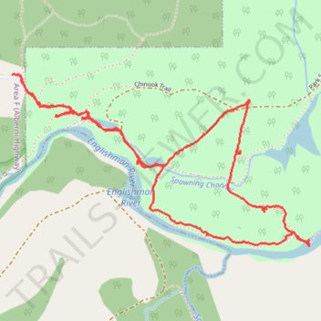
Name: Cougar trails trail, distance, elevation, map, profile, GPS track
Coordinates: 49.27946 -124.30731 49.28570 -124.29083
Other hiking, mountain biking, running and outdoor activity trails
Click on a trail to view its statistics, map and profile.
Sproat Lake - Nanaimo
Canada > British Columbia > Alberni-Clayoquot Regional District > Area D (Sproat Lake)
Distance: 54.0 mi • Elevation gain: 1,273 m • Maximum elevation: 422 m