Make a donation
Gear up for your next adventure:
As an Amazon Associate, this site earns from qualifying purchases at no extra cost to you.
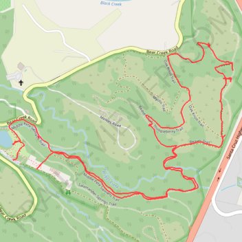
Lower Pete Siemens Trail, Bear Creek Redwoods, CA
- Distance: 3.4 mi
- Elevation gain: 128 m
- Maximum elevation: 302 m
- Elevation loss: 129 m
- Minimum elevation: 225 m
- Moving time: 1 h 33 m
- Moving speed: 2.1 mph
- Maximum speed: 13.2 mph
- Total time: 1 h 45 m
- Global speed: 1.9 mph
Interactive trail map
Make a donation
Gear up for your next adventure:
As an Amazon Associate, this site earns from qualifying purchases at no extra cost to you.
Trail profile
- Distance: 3.4 mi
- Elevation gain: 128 m
- Maximum elevation: 302 m
- Elevation loss: 129 m
- Minimum elevation: 225 m
- Moving time: 1 h 33 m
- Moving speed: 2.1 mph
- Maximum speed: 13.2 mph
- Total time: 1 h 45 m
- Global speed: 1.9 mph
Make a donation
Gear up for your next adventure:
As an Amazon Associate, this site earns from qualifying purchases at no extra cost to you.
About this trail
Name: Lower Pete Siemens Trail, Bear Creek Redwoods, CA trail, distance, elevation, map, profile, GPS track
End: Bear Creek Road, Santa Clara County, California, United States (37.18266 -122.00385)
Coordinates: 37.18103 -122.00404 37.18744 -121.99255
Make a donation
Gear up for your next adventure:
As an Amazon Associate, this site earns from qualifying purchases at no extra cost to you.
Other hiking, mountain biking, running and outdoor activity trails
Click on a trail to view its statistics, map and profile.
Myotis and Toad Hollow Trails, Bear Creek Redwoods, CA
United States > California > Santa Clara County
Distance: 3.7 mi • Elevation gain: 164 m • Maximum elevation: 303 m
Thimbleberry Trail, Bear Creek Redwoods, CA
United States > California > Santa Clara County
Distance: 3.1 mi • Elevation gain: 142 m • Maximum elevation: 300 m