Import a GPX file

Morning Mountain Bike Ride

  • Distance: 5.5 mi
  • Elevation gain: 252 m
  • Maximum elevation: 2,212 m
  • Elevation loss: 252 m
  • Minimum elevation: 2,047 m
  • Moving time: 36 m 32 s
  • Moving speed: 9.0 mph
  • Maximum speed: 22.1 mph
  • Total time: 37 m 47 s
  • Global speed: 8.7 mph

Interactive trail map

Trail profile

  • Distance: 5.5 mi
  • Elevation gain: 252 m
  • Maximum elevation: 2,212 m
  • Elevation loss: 252 m
  • Minimum elevation: 2,047 m
  • Moving time: 36 m 32 s
  • Moving speed: 9.0 mph
  • Maximum speed: 22.1 mph
  • Total time: 37 m 47 s
  • Global speed: 8.7 mph

About this trail
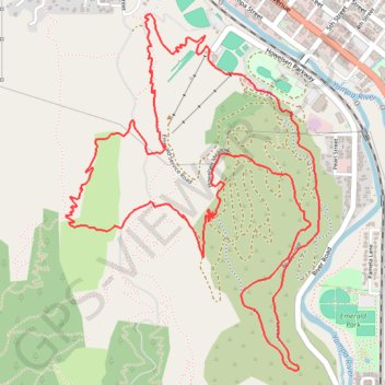
Name: Morning Mountain Bike Ride trail, distance, elevation, map, profile, GPS track

Start: Yampa River Core Trail, Steamboat Springs, Routt County, Colorado, 80487, United States (40.48343 -106.83823)

End: Yampa River Core Trail, Steamboat Springs, Routt County, Colorado, 80487, United States (40.48342 -106.83824)

Coordinates: 40.46893 -106.84686 40.48520 -106.83162

Gear up for your next adventure:

📢Survival Whistles - Essential safety gear for signaling for help in mountain fog
📷Camera Straps - Secure straps for carrying cameras while walking
🧣Neck Gaiters - Versatile protection against wind and cold
🌦️Portable Weather Meters - Handheld tools for monitoring weather conditions
🔋Power Banks - Portable chargers for long outdoor trips

As an Amazon Associate, this site earns from qualifying purchases at no extra cost to you.