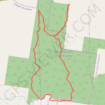
Peachester State Forest
#Hiking #Loop #Peachester
- Distance: 7.3 mi
- Elevation gain: 188 m
- Maximum elevation: 209 m
- Elevation loss: 187 m
- Minimum elevation: 130 m
Interactive trail map
Trail profile
- Distance: 7.3 mi
- Elevation gain: 188 m
- Maximum elevation: 209 m
- Elevation loss: 187 m
- Minimum elevation: 130 m
About this trail
Name: Peachester State Forest trail, distance, elevation, map, profile, GPS track
Start: Reserve Road, Peachester, Sunshine Coast Regional, Queensland, Australia (-26.85693 152.85974)
End: Reserve Road, Peachester, Sunshine Coast Regional, Queensland, Australia (-26.85693 152.85986)
Coordinates: -26.88797 152.84605 -26.85693 152.86134
Other hiking, mountain biking, running and outdoor activity trails
Click on a trail to view its statistics, map and profile.