Import a GPX file

Irawan

#Hiking

  • Distance: 1.8 mi
  • Elevation gain: 76 m
  • Maximum elevation: 61 m
  • Elevation loss: 57 m
  • Minimum elevation: 29 m

Interactive trail map

Trail profile

  • Distance: 1.8 mi
  • Elevation gain: 76 m
  • Maximum elevation: 61 m
  • Elevation loss: 57 m
  • Minimum elevation: 29 m

About this trail

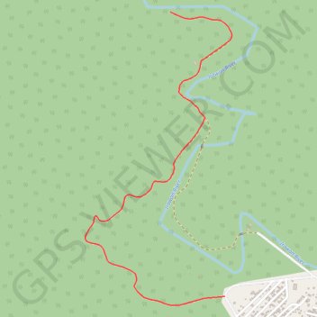
Name: Irawan trail, distance, elevation, map, profile, GPS track

Start: Irawan, Puerto Princesa, Mimaropa, Philippines (9.80447 118.68123)

End: Irawan, Puerto Princesa, Mimaropa, Philippines (9.81741 118.67871)

Coordinates: 9.80406 118.67478 9.81741 118.68155

Gear up for your next adventure:

📸Action Camera Chest Mounts - Record your ascent following topographic paths hands-free
🛰️Handheld GPS Devices - Reliable GPS units for hiking and outdoor navigation
🥄Titanium Camping Sporks - The ultimate lightweight utensil for trail meals
🚲Bikepacking Frame Bags - Storage for tools and navigation gear on long off-road rides
🛰️Satellite Messengers - Emergency communication devices for areas without mobile signal

As an Amazon Associate, this site earns from qualifying purchases at no extra cost to you.