Thank you for supporting this site ❤️
Make a donation
Make a donation
Gear up for your next adventure:
As an Amazon Associate, this site earns from qualifying purchases at no extra cost to you.
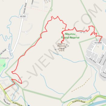
Sleeping Giant / Nounou (Kauai Island)
Hike to Sleeping Giant in the Nounou Forest Reserve on Kauai Island. #Hiking #Nature #Forest #Mountain #Sea #Pacific #Ocean #Island #Hawaii
- Distance: 3.8 mi
- Elevation gain: 395 m
- Maximum elevation: 329 m
- Elevation loss: 349 m
- Minimum elevation: 46 m
- Moving time: 2 h 1 m
- Moving speed: 1.9 mph
- Maximum speed: 5.9 mph
- Total time: 2 h 54 m
- Global speed: 1.3 mph
Interactive trail map
Thank you for supporting this site ❤️
Make a donation
Make a donation
Gear up for your next adventure:
As an Amazon Associate, this site earns from qualifying purchases at no extra cost to you.
Trail profile
- Distance: 3.8 mi
- Elevation gain: 395 m
- Maximum elevation: 329 m
- Elevation loss: 349 m
- Minimum elevation: 46 m
- Moving time: 2 h 1 m
- Moving speed: 1.9 mph
- Maximum speed: 5.9 mph
- Total time: 2 h 54 m
- Global speed: 1.3 mph
Thank you for supporting this site ❤️
Make a donation
Make a donation
Gear up for your next adventure:
As an Amazon Associate, this site earns from qualifying purchases at no extra cost to you.
About this trail
Name: Sleeping Giant / Nounou (Kauai Island) trail, distance, elevation, map, profile, GPS track
Coordinates: 22.05154 -159.36749 22.06662 -159.34589
Thank you for supporting this site ❤️
Make a donation
Make a donation
Gear up for your next adventure:
As an Amazon Associate, this site earns from qualifying purchases at no extra cost to you.