Thank you for supporting this site ❤️
Make a donation
Make a donation
Gear up for your next adventure:
As an Amazon Associate, this site earns from qualifying purchases at no extra cost to you.
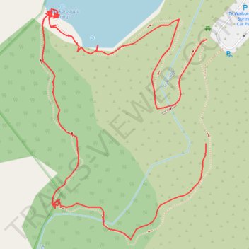
Te Waikoropupū Springs walking trail
- Distance: 0.6 mi
- Elevation gain: 9 m
- Maximum elevation: 33 m
- Elevation loss: 16 m
- Minimum elevation: 16 m
- Moving time: 18 m
- Moving speed: 2.0 mph
- Maximum speed: 4.1 mph
- Total time: 30 m 6 s
- Global speed: 1.2 mph
Interactive trail map
Thank you for supporting this site ❤️
Make a donation
Make a donation
Gear up for your next adventure:
As an Amazon Associate, this site earns from qualifying purchases at no extra cost to you.
Trail profile
- Distance: 0.6 mi
- Elevation gain: 9 m
- Maximum elevation: 33 m
- Elevation loss: 16 m
- Minimum elevation: 16 m
- Moving time: 18 m
- Moving speed: 2.0 mph
- Maximum speed: 4.1 mph
- Total time: 30 m 6 s
- Global speed: 1.2 mph
Thank you for supporting this site ❤️
Make a donation
Make a donation
Gear up for your next adventure:
As an Amazon Associate, this site earns from qualifying purchases at no extra cost to you.
About this trail
Name: Te Waikoropupū Springs walking trail trail, distance, elevation, map, profile, GPS track
Start: Pupū Springs Road, Tākaka, Tasman District, Tasman, 7110, New Zealand (-40.84913 172.77044)
Coordinates: -40.85002 172.76844 -40.84789 172.77045
Thank you for supporting this site ❤️
Make a donation
Make a donation
Gear up for your next adventure:
As an Amazon Associate, this site earns from qualifying purchases at no extra cost to you.
Other hiking, mountain biking, running and outdoor activity trails
Click on a trail to view its statistics, map and profile.