Make a donation
Gear up for your next adventure:
As an Amazon Associate, this site earns from qualifying purchases at no extra cost to you.
Conham - River Avon
Interactive trail map
Make a donation
Gear up for your next adventure:
As an Amazon Associate, this site earns from qualifying purchases at no extra cost to you.
Trail profile
- Distance: 4.0 mi
- Elevation gain: 149 m
- Maximum elevation: 57 m
- Elevation loss: 149 m
- Minimum elevation: 3 m
Make a donation
Gear up for your next adventure:
As an Amazon Associate, this site earns from qualifying purchases at no extra cost to you.
About this trail
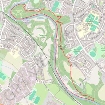
Name: Conham - River Avon trail, distance, elevation, map, profile, GPS track
Coordinates: 51.43069 -2.53926 51.44725 -2.51643
Topography: Bristol topographic map, elevation, terrain
Make a donation
Gear up for your next adventure:
As an Amazon Associate, this site earns from qualifying purchases at no extra cost to you.
Other hiking, mountain biking, running and outdoor activity trails
Click on a trail to view its statistics, map and profile.
2024-03-30_10-35_Sat
United Kingdom > England > City of Bristol > Bristol
Distance: 13.3 mi • Elevation gain: 200 m • Maximum elevation: 59 m
Dean2023-311
United Kingdom > England > Oxfordshire > Oxford
Distance: 192.8 mi • Elevation gain: 3,366 m • Maximum elevation: 290 m