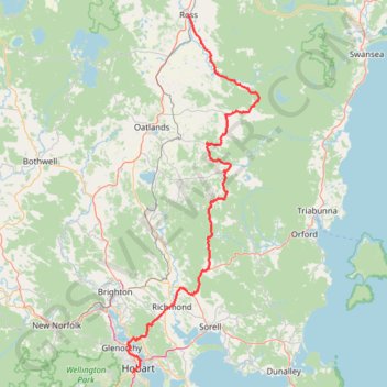
Import a GPX file

Ross - Hobart

#Bike #Tasmania

  • Distance: 98.9 mi
  • Elevation gain: 2,267 m
  • Maximum elevation: 552 m
  • Elevation loss: 2,386 m
  • Minimum elevation: 0 m

Interactive trail map

Trail profile

  • Distance: 98.9 mi
  • Elevation gain: 2,267 m
  • Maximum elevation: 552 m
  • Elevation loss: 2,386 m
  • Minimum elevation: 0 m

About this trail

Name: Ross - Hobart trail, distance, elevation, map, profile, GPS track

Start: Church Street, Ross, Northern Midlands, Tasmania, 7209, Australia (-42.03103 147.49223)

End: Glen Street, South Hobart, Hobart, City of Hobart, Tasmania, 7004, Australia (-42.89453 147.30865)

Coordinates: -42.89468 147.29466 -42.03103 147.72436

Other hiking, mountain biking, running and outdoor activity trails

Click on a trail to view its statistics, map and profile.

Droughty Ridgeline Trail North (Rokeby Hills)

Australia > Tasmania > Hobart

This trail runs the ridgeline of the Rokeby Hills Bushland Reserve. Starting at the end of Mayfair Crt enter the reserve and head straight up to the top of Kuynah reserve. From here there are blue markers(arrows) to keep users on the primary ridgeline track which is also the fire trail along the reserve. The…

Distance: 2.4 mi • Elevation gain: 121 m • Maximum elevation: 155 m

South Hobart - Glenlusk - Derwent River - Moelsworth

Australia > Tasmania > Hobart

#Bike #Loop #Tasmania

Distance: 42.8 mi • Elevation gain: 1,092 m • Maximum elevation: 434 m

South Hobart - Wellington Park - Pipeline Track

Australia > Tasmania > Hobart

#Bike #Wellington #Tasmania

Distance: 13.2 mi • Elevation gain: 988 m • Maximum elevation: 636 m

South Hobart - Howrah - Bowen Bridge

Australia > Tasmania > Hobart

#Bike #Loop #Tasmania

Distance: 31.0 mi • Elevation gain: 599 m • Maximum elevation: 72 m

Hobart - Mount Field Loop

Australia > Tasmania > Hobart

#Bike #Loop #Tasmania

Distance: 127.3 mi • Elevation gain: 2,722 m • Maximum elevation: 460 m

Hobart Ride

Australia > Tasmania > Hobart

#Bike #Loop #Tasmania

Distance: 10.5 mi • Elevation gain: 278 m • Maximum elevation: 71 m

Gear up for your next adventure:

📱Phone Mounts for Hiking - Secure mounts to carry your phone on trails
🛰️Handheld GPS Devices - Reliable GPS units for hiking and outdoor navigation
🧢Waterproof Hiking Hats - Keep the rain off your face while studying topographic maps
🐕Dog Hiking Gear - Equipment for hiking safely with dogs
🥫Expedition Meals - Lightweight, high-calorie nutrition for long-distance hikers

As an Amazon Associate, this site earns from qualifying purchases at no extra cost to you.