Cefn coed
- Distance: 3.0 mi
- Elevation gain: 147 m
- Maximum elevation: 281 m
- Elevation loss: 112 m
- Minimum elevation: 202 m
- Moving time: 1 h 3 m
- Moving speed: 2.8 mph
- Maximum speed: 4.0 mph
- Total time: 1 h 15 m
- Global speed: 2.3 mph
Interactive trail map
Trail profile
- Distance: 3.0 mi
- Elevation gain: 147 m
- Maximum elevation: 281 m
- Elevation loss: 112 m
- Minimum elevation: 202 m
- Moving time: 1 h 3 m
- Moving speed: 2.8 mph
- Maximum speed: 4.0 mph
- Total time: 1 h 15 m
- Global speed: 2.3 mph
About this trail
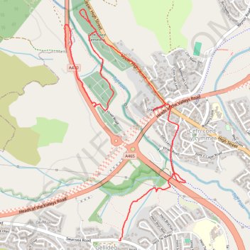
Name: Cefn coed trail, distance, elevation, map, profile, GPS track
Coordinates: 51.75409 -3.41766 51.76926 -3.40485
Topography: Rhondda Cynon Taf topographic map, elevation, terrain
Other hiking, mountain biking, running and outdoor activity trails
Click on a trail to view its statistics, map and profile.
The Headstock 500
United Kingdom > Wales > Newport > Newport
Distance: 300.4 mi • Elevation gain: 9,616 m • Maximum elevation: 691 m
Treorchy, Cearphilly, Pen y Fan
United Kingdom > Wales > Caerphilly County Borough > Tredegar
Distance: 79.1 mi • Elevation gain: 1,934 m • Maximum elevation: 501 m