Thank you for supporting this site ❤️
Make a donation
Make a donation
Gear up for your next adventure:
As an Amazon Associate, this site earns from qualifying purchases at no extra cost to you.
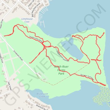
South River Farm Park
- Distance: 3.0 mi
- Elevation gain: 49 m
- Maximum elevation: 14 m
- Elevation loss: 49 m
- Minimum elevation: 1 m
- Moving time: 1 h 26 m
- Moving speed: 2.1 mph
- Maximum speed: 12.9 mph
- Total time: 1 h 41 m
- Global speed: 1.8 mph
Interactive trail map
Thank you for supporting this site ❤️
Make a donation
Make a donation
Gear up for your next adventure:
As an Amazon Associate, this site earns from qualifying purchases at no extra cost to you.
Trail profile
- Distance: 3.0 mi
- Elevation gain: 49 m
- Maximum elevation: 14 m
- Elevation loss: 49 m
- Minimum elevation: 1 m
- Moving time: 1 h 26 m
- Moving speed: 2.1 mph
- Maximum speed: 12.9 mph
- Total time: 1 h 41 m
- Global speed: 1.8 mph
Thank you for supporting this site ❤️
Make a donation
Make a donation
Gear up for your next adventure:
As an Amazon Associate, this site earns from qualifying purchases at no extra cost to you.
About this trail
Name: South River Farm Park trail, distance, elevation, map, profile, GPS track
Coordinates: 38.91508 -76.51999 38.92035 -76.50879
Thank you for supporting this site ❤️
Make a donation
Make a donation
Gear up for your next adventure:
As an Amazon Associate, this site earns from qualifying purchases at no extra cost to you.