Thank you for supporting this site ❤️
Make a donation
Make a donation
Gear up for your next adventure:
As an Amazon Associate, this site earns from qualifying purchases at no extra cost to you.
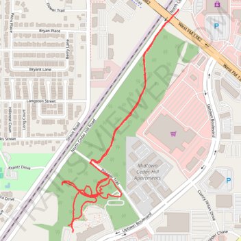
Cedar Hill Signature Trail
- Distance: 2.3 mi
- Elevation gain: 22 m
- Maximum elevation: 244 m
- Elevation loss: 23 m
- Minimum elevation: 230 m
- Moving time: 42 m 17 s
- Moving speed: 3.3 mph
- Maximum speed: 5.6 mph
- Total time: 48 m 27 s
- Global speed: 2.8 mph
Interactive trail map
Thank you for supporting this site ❤️
Make a donation
Make a donation
Gear up for your next adventure:
As an Amazon Associate, this site earns from qualifying purchases at no extra cost to you.
Trail profile
- Distance: 2.3 mi
- Elevation gain: 22 m
- Maximum elevation: 244 m
- Elevation loss: 23 m
- Minimum elevation: 230 m
- Moving time: 42 m 17 s
- Moving speed: 3.3 mph
- Maximum speed: 5.6 mph
- Total time: 48 m 27 s
- Global speed: 2.8 mph
Thank you for supporting this site ❤️
Make a donation
Make a donation
Gear up for your next adventure:
As an Amazon Associate, this site earns from qualifying purchases at no extra cost to you.
About this trail
Name: Cedar Hill Signature Trail trail, distance, elevation, map, profile, GPS track
Start: Blink, Uptown Boulevard, Cedar Hill, Dallas County, Texas, 75104, United States (32.59325 -96.95181)
End: Uptown Boulevard, Cedar Hill, Dallas County, Texas, 75104, United States (32.59354 -96.95203)
Coordinates: 32.59325 -96.95232 32.60257 -96.94655
Thank you for supporting this site ❤️
Make a donation
Make a donation
Gear up for your next adventure:
As an Amazon Associate, this site earns from qualifying purchases at no extra cost to you.