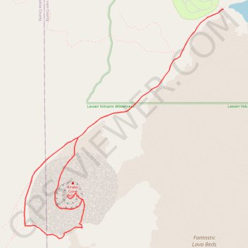
Cinder Cone Trail
- Distance: 4.7 mi
- Elevation gain: 326 m
- Maximum elevation: 2,083 m
- Elevation loss: 326 m
- Minimum elevation: 1,857 m
Interactive trail map
Trail profile
- Distance: 4.7 mi
- Elevation gain: 326 m
- Maximum elevation: 2,083 m
- Elevation loss: 326 m
- Minimum elevation: 1,857 m
About this trail
Name: Cinder Cone Trail trail, distance, elevation, map, profile, GPS track
Start: Butte Lake To Snag Lake Trail, Lassen County, California, United States (40.56385 -121.30210)
End: Butte Lake To Snag Lake Trail, Lassen County, California, United States (40.56385 -121.30209)
Coordinates: 40.54358 -121.32527 40.56385 -121.30209