Half loop around the Small Crater
חצי סובב המכתש הקטן: שער אשמדאי, מעלה עלי ונחל מצלעות
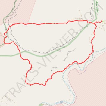
- Distance: 13.8 mi
- Elevation gain: 862 m
- Maximum elevation: 504 m
- Elevation loss: 862 m
- Minimum elevation: -115 m
- Moving time: 6 h 52 m
- Moving speed: 2.0 mph
- Maximum speed: 2.6 mph
- Total time: 6 h 52 m
- Global speed: 2.0 mph
Interactive trail map
Trail profile
- Distance: 13.8 mi
- Elevation gain: 862 m
- Maximum elevation: 504 m
- Elevation loss: 862 m
- Minimum elevation: -115 m
- Moving time: 6 h 52 m
- Moving speed: 2.0 mph
- Maximum speed: 2.6 mph
- Total time: 6 h 52 m
- Global speed: 2.0 mph
About this trail
Name: Half loop around the Small Crater trail, distance, elevation, map, profile, GPS track
Coordinates: 30.91442 35.15796 30.95295 35.22578
Other hiking, mountain biking, running and outdoor activity trails
Click on a trail to view its statistics, map and profile.
Akrabim and Tzafir
Israel > South District > Tamar Regional Council
עקרבים וצפיר: על התפר שבין הנגב לערבה: מעלה עקרבים ומעלה צפיר
Distance: 11.4 mi • Elevation gain: 673 m • Maximum elevation: 521 m