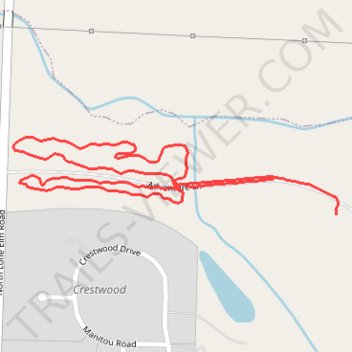
Momentum Bike Park - Southwest Area
- Distance: 1.4 mi
- Elevation gain: 19 m
- Maximum elevation: 288 m
- Elevation loss: 18 m
- Minimum elevation: 280 m
- Moving time: 10 m 21 s
- Moving speed: 8.1 mph
- Maximum speed: 19.7 mph
- Total time: 11 m 52 s
- Global speed: 7.1 mph
Interactive trail map
Trail profile
- Distance: 1.4 mi
- Elevation gain: 19 m
- Maximum elevation: 288 m
- Elevation loss: 18 m
- Minimum elevation: 280 m
- Moving time: 10 m 21 s
- Moving speed: 8.1 mph
- Maximum speed: 19.7 mph
- Total time: 11 m 52 s
- Global speed: 7.1 mph
About this trail
Name: Momentum Bike Park - Southwest Area trail, distance, elevation, map, profile, GPS track
Start: Adventure Ln, Joplin, Jasper County, Missouri, 64801, United States (37.10910 -94.51832)
End: Adventure Ln, Joplin, Jasper County, Missouri, 64801, United States (37.10973 -94.51972)
Coordinates: 37.10910 -94.52556 37.11049 -94.51826
Other hiking, mountain biking, running and outdoor activity trails
Click on a trail to view its statistics, map and profile.
Momentum Bike Park - Southern Green Trails
United States > Missouri > Jasper County > Joplin
Distance: 5.7 mi • Elevation gain: 34 m • Maximum elevation: 286 m