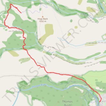
Hogs Back Track to Picnic Rock Lookout in Craigieburn Forest Park
- Distance: 8.0 mi
- Elevation gain: 470 m
- Maximum elevation: 1,055 m
- Elevation loss: 454 m
- Minimum elevation: 733 m
- Moving time: 3 h 19 m
- Moving speed: 2.4 mph
- Maximum speed: 3.5 mph
- Total time: 4 h 24 m
- Global speed: 1.8 mph
Interactive trail map
Trail profile
- Distance: 8.0 mi
- Elevation gain: 470 m
- Maximum elevation: 1,055 m
- Elevation loss: 454 m
- Minimum elevation: 733 m
- Moving time: 3 h 19 m
- Moving speed: 2.4 mph
- Maximum speed: 3.5 mph
- Total time: 4 h 24 m
- Global speed: 1.8 mph
About this trail
Name: Hogs Back Track to Picnic Rock Lookout in Craigieburn Forest Park trail, distance, elevation, map, profile, GPS track
Start: 43A, Trelissick Loop, Castle Hill Village, Selwyn District, 7580, New Zealand (-43.20868 171.71131)
End: Castle Hill Village, Selwyn District, New Zealand (-43.20618 171.71066)
Coordinates: -43.20877 171.67149 -43.17885 171.71212
Other hiking, mountain biking, running and outdoor activity trails
Click on a trail to view its statistics, map and profile.