Import a GPX file

Loop walk in Savory Park via Strachan Trail along Florence Lake

  • Distance: 0.8 mi
  • Elevation gain: 20 m
  • Maximum elevation: 92 m
  • Elevation loss: 22 m
  • Minimum elevation: 78 m
  • Moving time: 23 m 8 s
  • Moving speed: 2.1 mph
  • Maximum speed: 4.8 mph
  • Total time: 26 m 3 s
  • Global speed: 1.9 mph

Interactive trail map

Trail profile

  • Distance: 0.8 mi
  • Elevation gain: 20 m
  • Maximum elevation: 92 m
  • Elevation loss: 22 m
  • Minimum elevation: 78 m
  • Moving time: 23 m 8 s
  • Moving speed: 2.1 mph
  • Maximum speed: 4.8 mph
  • Total time: 26 m 3 s
  • Global speed: 1.9 mph

About this trail

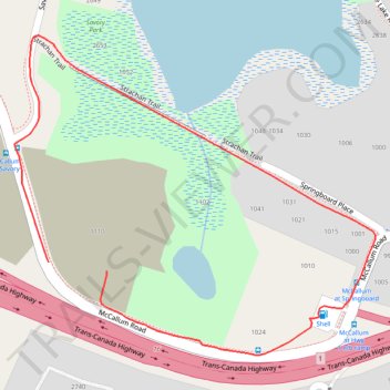
Name: Loop walk in Savory Park via Strachan Trail along Florence Lake trail, distance, elevation, map, profile, GPS track

Start: 1110, McCallum Road, Langford, Capital Regional District, British Columbia, V9B 4C6, Canada (48.45420 -123.51485)

End: 1110, McCallum Road, Langford, Capital Regional District, British Columbia, V9B 4C6, Canada (48.45410 -123.51387)

Coordinates: 48.45316 -123.51543 48.45676 -123.50931

Gear up for your next adventure:

🔋Rechargeable Batteries - Eco-friendly power for headlamps and older GPS units
👖Convertible Hiking Trousers - Versatile zip-off pants for changing mountain weather conditions
🗺️Ordnance Survey Maps - Essential paper maps for hiking across the UK national parks
🪢Paracord - Multi-purpose cord for camping and survival
🔦LED Camping Lanterns - Illumination for reading maps inside your tent at night

As an Amazon Associate, this site earns from qualifying purchases at no extra cost to you.