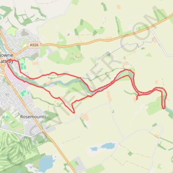
Mountain bike ride to Kitty Swanson's Bridge over River Ericht
- Distance: 8.5 mi
- Elevation gain: 84 m
- Maximum elevation: 70 m
- Elevation loss: 84 m
- Minimum elevation: 36 m
- Moving time: 1 h 11 m
- Moving speed: 7.1 mph
- Maximum speed: 18.2 mph
- Total time: 1 h 42 m
- Global speed: 5.0 mph
Interactive trail map
Trail profile
- Distance: 8.5 mi
- Elevation gain: 84 m
- Maximum elevation: 70 m
- Elevation loss: 84 m
- Minimum elevation: 36 m
- Moving time: 1 h 11 m
- Moving speed: 7.1 mph
- Maximum speed: 18.2 mph
- Total time: 1 h 42 m
- Global speed: 5.0 mph
About this trail
Name: Mountain bike ride to Kitty Swanson's Bridge over River Ericht trail, distance, elevation, map, profile, GPS track
Coordinates: 56.57839 -3.33599 56.59230 -3.26088
Topography: Perth and Kinross topographic map, elevation, terrain
Other hiking, mountain biking, running and outdoor activity trails
Click on a trail to view its statistics, map and profile.
Loop Gravel Ride around Blairgowrie and Rattray between Loch of Clunie and Alyth
United Kingdom > Scotland > Perth and Kinross > Newlands
Distance: 24.7 mi • Elevation gain: 529 m • Maximum elevation: 281 m
Around Blairgowrie, Scotland
United Kingdom > Scotland > Perth and Kinross > Craigie
UK, Perthshire, Blairgowrie
Distance: 12.2 mi • Elevation gain: 174 m • Maximum elevation: 81 m