Make a donation
Gear up for your next adventure:
As an Amazon Associate, this site earns from qualifying purchases at no extra cost to you.
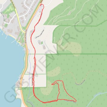
Monkey Rock via Tunnel Creek Road in Lake Tahoe Nevada State Park
The hike to Monkey Rock in Lake Tahoe Nevada State Park is a short but moderately challenging trail that rewards you with stunning panoramic views of the lake. Starting near Tunnel Creek Café, the trail climbs steadily through a mix of forest and exposed terrain, offering great lookout points along the way. The monkey-shaped rock formation near the summit makes for a fun and memorable photo stop, and the serene vistas of Lake Tahoe are well worth the effort. Perfect for a quick, scenic adventure with just enough uphill to get your heart pumping. #Hiking #Mountain #Lake #Forest #Nature
- Distance: 2.5 mi
- Elevation gain: 156 m
- Maximum elevation: 2,062 m
- Elevation loss: 151 m
- Minimum elevation: 1,922 m
- Moving time: 1 h 2 m
- Moving speed: 2.3 mph
- Maximum speed: 16.7 mph
- Total time: 1 h 47 m
- Global speed: 1.4 mph
Interactive trail map
Make a donation
Gear up for your next adventure:
As an Amazon Associate, this site earns from qualifying purchases at no extra cost to you.
Trail profile
- Distance: 2.5 mi
- Elevation gain: 156 m
- Maximum elevation: 2,062 m
- Elevation loss: 151 m
- Minimum elevation: 1,922 m
- Moving time: 1 h 2 m
- Moving speed: 2.3 mph
- Maximum speed: 16.7 mph
- Total time: 1 h 47 m
- Global speed: 1.4 mph
Make a donation
Gear up for your next adventure:
As an Amazon Associate, this site earns from qualifying purchases at no extra cost to you.
About this trail
Name: Monkey Rock via Tunnel Creek Road in Lake Tahoe Nevada State Park trail, distance, elevation, map, profile, GPS track
Coordinates: 39.22456 -119.93143 39.23510 -119.92518
Make a donation
Gear up for your next adventure:
As an Amazon Associate, this site earns from qualifying purchases at no extra cost to you.
Other hiking, mountain biking, running and outdoor activity trails
Click on a trail to view its statistics, map and profile.
Monkey Rock Trail in Lake Tahoe Basin Management Unit
United States > Nevada > Washoe County > Incline Village-Crystal Bay
The Monkey Rock Trail via Tunnel Creek Road in the Lake Tahoe Basin Management Unit is a scenic, moderately challenging hike that offers hikers beautiful views of the surrounding wilderness. As you ascend, the trail provides expansive views of Lake Tahoe's azure waters framed by the surrounding Sierra Nevada…
Distance: 2.6 mi • Elevation gain: 155 m • Maximum elevation: 2,061 m
Tahoe Rim Trail (TRT) - Marlette Peak - Incline Flume
United States > Nevada > Washoe County > Incline Village-Crystal Bay
Distance: 28.9 mi • Elevation gain: 1,381 m • Maximum elevation: 2,690 m
Tahoe Rim Trail (TRT) - Marlette Peak - Flumes
United States > Nevada > Washoe County > Incline Village-Crystal Bay
Distance: 30.9 mi • Elevation gain: 1,411 m • Maximum elevation: 2,690 m
Make a donation
Gear up for your next adventure:
As an Amazon Associate, this site earns from qualifying purchases at no extra cost to you.