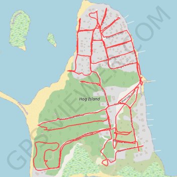
Hog Island
Portsmouth Running
- Distance: 7.0 mi
- Elevation gain: 54 m
- Maximum elevation: 8 m
- Elevation loss: 54 m
- Minimum elevation: -1 m
- Moving time: 1 h 11 m
- Moving speed: 5.9 mph
- Maximum speed: 11.3 mph
- Total time: 1 h 15 m
- Global speed: 5.6 mph
Interactive trail map
Trail profile
- Distance: 7.0 mi
- Elevation gain: 54 m
- Maximum elevation: 8 m
- Elevation loss: 54 m
- Minimum elevation: -1 m
- Moving time: 1 h 11 m
- Moving speed: 5.9 mph
- Maximum speed: 11.3 mph
- Total time: 1 h 15 m
- Global speed: 5.6 mph
About this trail
Name: Hog Island trail, distance, elevation, map, profile, GPS track
Start: Riverside Drive, Portsmouth, Newport County, Rhode Island, 02809, United States (41.64383 -71.27693)
End: Riverside Drive, Portsmouth, Newport County, Rhode Island, 02809, United States (41.64397 -71.27703)
Coordinates: 41.63862 -71.28505 41.64776 -71.27682