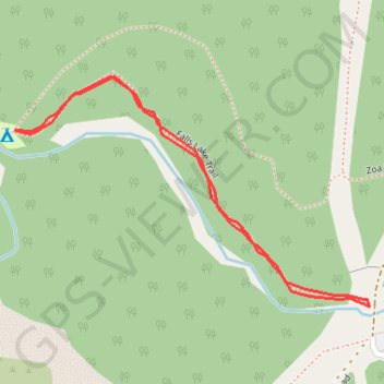
Falls Lake
Coquihalla Summit Recreation Area. #Hiking #Falls #Coquihalla
- Distance: 0.9 mi
- Elevation gain: 78 m
- Maximum elevation: 1,312 m
- Elevation loss: 79 m
- Minimum elevation: 1,249 m
Interactive trail map
Trail profile
- Distance: 0.9 mi
- Elevation gain: 78 m
- Maximum elevation: 1,312 m
- Elevation loss: 79 m
- Minimum elevation: 1,249 m
About this trail
Name: Falls Lake trail, distance, elevation, map, profile, GPS track
Coordinates: 49.61273 -121.07260 49.61588 -121.06508
Other hiking, mountain biking, running and outdoor activity trails
Click on a trail to view its statistics, map and profile.
Zoa Peak
Canada > British Columbia > Fraser Valley Regional District > Area B (South Fraser Canyon/Sunshine Valley)
Coquihalla Summit Recreation Area. #Hiking #CoquihallaSummit
Distance: 6.1 mi • Elevation gain: 695 m • Maximum elevation: 1,845 m