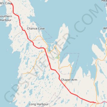
Arnold's Cove - Whitbourne
#Bike #ArnoldsCove #Whitbourne #Newfoundland
- Distance: 31.4 mi
- Elevation gain: 719 m
- Maximum elevation: 199 m
- Elevation loss: 707 m
- Minimum elevation: 28 m
Interactive trail map
Trail profile
- Distance: 31.4 mi
- Elevation gain: 719 m
- Maximum elevation: 199 m
- Elevation loss: 707 m
- Minimum elevation: 28 m
About this trail
Name: Arnold's Cove - Whitbourne trail, distance, elevation, map, profile, GPS track
Coordinates: 47.44840 -53.94280 47.75726 -53.55219
Other hiking, mountain biking, running and outdoor activity trails
Click on a trail to view its statistics, map and profile.
Whitbourne - St. John's
Canada > Newfoundland and Labrador > Whitbourne
#Bike #Whitbourne #StJohns #Newfoundland #Atlantic
Distance: 64.2 mi • Elevation gain: 1,230 m • Maximum elevation: 234 m
Mallorytown - Arnold's Cove
Canada > Newfoundland and Labrador
#Bike #Mallorytown #ArnoldsCove #Newfoundland
Distance: 73.7 mi • Elevation gain: 1,182 m • Maximum elevation: 149 m
Argentia - Whitbourne
Canada > Newfoundland and Labrador > Placentia
Distance: 28.5 mi • Elevation gain: 453 m • Maximum elevation: 183 m