Thank you for supporting this site ❤️
Make a donation
Make a donation
Gear up for your next adventure:
As an Amazon Associate, this site earns from qualifying purchases at no extra cost to you.
Cave-tastic
- Distance: 5.1 mi
- Elevation gain: 444 m
- Maximum elevation: 619 m
- Elevation loss: 444 m
- Minimum elevation: 390 m
- Moving time: 1 h 19 m
- Moving speed: 3.8 mph
- Maximum speed: 7.8 mph
- Total time: 1 h 19 m
- Global speed: 3.8 mph
Interactive trail map
Thank you for supporting this site ❤️
Make a donation
Make a donation
Gear up for your next adventure:
As an Amazon Associate, this site earns from qualifying purchases at no extra cost to you.
Trail profile
- Distance: 5.1 mi
- Elevation gain: 444 m
- Maximum elevation: 619 m
- Elevation loss: 444 m
- Minimum elevation: 390 m
- Moving time: 1 h 19 m
- Moving speed: 3.8 mph
- Maximum speed: 7.8 mph
- Total time: 1 h 19 m
- Global speed: 3.8 mph
Thank you for supporting this site ❤️
Make a donation
Make a donation
Gear up for your next adventure:
As an Amazon Associate, this site earns from qualifying purchases at no extra cost to you.
About this trail
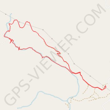
Name: Cave-tastic trail, distance, elevation, map, profile, GPS track
Start: Deira Al-Tamba, Tawyeen, Fujairah Emirate, United Arab Emirates (25.60787 56.12212)
End: Deira Al-Tamba, Tawyeen, Fujairah Emirate, United Arab Emirates (25.60794 56.12211)
Coordinates: 25.60690 56.09743 25.62233 56.12220
Thank you for supporting this site ❤️
Make a donation
Make a donation
Gear up for your next adventure:
As an Amazon Associate, this site earns from qualifying purchases at no extra cost to you.