Import a GPX file

Cornubia Forest Nature Reserve

#MTB #Loop #Cornubia

  • Distance: 10.5 mi
  • Elevation gain: 518 m
  • Maximum elevation: 144 m
  • Elevation loss: 522 m
  • Minimum elevation: 23 m

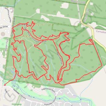
Interactive trail map

Trail profile

  • Distance: 10.5 mi
  • Elevation gain: 518 m
  • Maximum elevation: 144 m
  • Elevation loss: 522 m
  • Minimum elevation: 23 m

About this trail

Name: Cornubia Forest Nature Reserve trail, distance, elevation, map, profile, GPS track

Start: Parkview Access Trail, Cornubia, Greater Brisbane, Queensland, 4130, Australia (-27.65234 153.19379)

End: Parkview Crescent, Cornubia, Greater Brisbane, Queensland, 4130, Australia (-27.65450 153.19196)

Coordinates: -27.65453 153.19163 -27.64377 153.20996

Gear up for your next adventure:

🐕Hiking Dog Harnesses - Rugged harnesses for taking your companion on mountain trails
🥄Titanium Camping Sporks - The ultimate lightweight utensil for trail meals
🔦Waterproof LED Headlamps - Hands-free lighting for evening treks and emergency navigation
🕶️Glacier Goggles - Maximum protection for high-altitude snow topography
GPS Outdoor Watches - Watches with GPS tracking for hiking and exploration

As an Amazon Associate, this site earns from qualifying purchases at no extra cost to you.