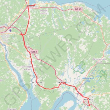
Shediac - Amherst
Interactive trail map
Trail profile
- Distance: 49.8 mi
- Elevation gain: 550 m
- Maximum elevation: 90 m
- Elevation loss: 547 m
- Minimum elevation: -1 m
About this trail
Name: Shediac - Amherst trail, distance, elevation, map, profile, GPS track
Coordinates: 45.80101 -64.61254 46.22559 -64.19895
Other hiking, mountain biking, running and outdoor activity trails
Click on a trail to view its statistics, map and profile.
Black River Bridge - Shédiac
Canada > New Brunswick > Glenelg Parish
Gulf of Saint Lawrence. #Bike #SaintLawrence #Atlantic
Distance: 71.4 mi • Elevation gain: 451 m • Maximum elevation: 37 m
Shédiac - Borden-Carleton
Canada > New Brunswick > Shediac Parish > Shediac
Gulf of Saint Lawrence. #Bike #Shédiac #BordenCarleton #SaintLawrence #Atlantic
Distance: 41.1 mi • Elevation gain: 294 m • Maximum elevation: 48 m
Amherst - Brookfield
Canada > Nova Scotia > Municipality of the County of Cumberland > Upper Nappan
Distance: 75.4 mi • Elevation gain: 1,019 m • Maximum elevation: 255 m