Thank you for supporting this site ❤️
Make a donation
Make a donation
Gear up for your next adventure:
As an Amazon Associate, this site earns from qualifying purchases at no extra cost to you.
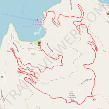
Mount Caroline Livermore loop hike via Sunset Trail and North Ridge Trail on Angel Island
- Distance: 4.2 mi
- Elevation gain: 352 m
- Maximum elevation: 188 m
- Elevation loss: 351 m
- Minimum elevation: 0 m
- Moving time: 1 h 44 m
- Moving speed: 2.4 mph
- Maximum speed: 5.9 mph
- Total time: 2 h 38 m
- Global speed: 1.6 mph
Interactive trail map
Thank you for supporting this site ❤️
Make a donation
Make a donation
Gear up for your next adventure:
As an Amazon Associate, this site earns from qualifying purchases at no extra cost to you.
Trail profile
- Distance: 4.2 mi
- Elevation gain: 352 m
- Maximum elevation: 188 m
- Elevation loss: 351 m
- Minimum elevation: 0 m
- Moving time: 1 h 44 m
- Moving speed: 2.4 mph
- Maximum speed: 5.9 mph
- Total time: 2 h 38 m
- Global speed: 1.6 mph
Thank you for supporting this site ❤️
Make a donation
Make a donation
Gear up for your next adventure:
As an Amazon Associate, this site earns from qualifying purchases at no extra cost to you.
About this trail
Name: Mount Caroline Livermore loop hike via Sunset Trail and North Ridge Trail on Angel Island trail, distance, elevation, map, profile, GPS track
Coordinates: 37.86016 -122.43856 37.87025 -122.42778
Thank you for supporting this site ❤️
Make a donation
Make a donation
Gear up for your next adventure:
As an Amazon Associate, this site earns from qualifying purchases at no extra cost to you.