Thank you for supporting this site ❤️
Make a donation
Make a donation
Gear up for your next adventure:
As an Amazon Associate, this site earns from qualifying purchases at no extra cost to you.
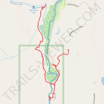
Hike from Devils Postpile to Minaret Falls
- Distance: 3.9 mi
- Elevation gain: 185 m
- Maximum elevation: 2,347 m
- Elevation loss: 150 m
- Minimum elevation: 2,305 m
- Moving time: 2 h 11 s
- Moving speed: 2.0 mph
- Maximum speed: 14.9 mph
- Total time: 2 h 52 m
- Global speed: 1.4 mph
Interactive trail map
Thank you for supporting this site ❤️
Make a donation
Make a donation
Gear up for your next adventure:
As an Amazon Associate, this site earns from qualifying purchases at no extra cost to you.
Trail profile
- Distance: 3.9 mi
- Elevation gain: 185 m
- Maximum elevation: 2,347 m
- Elevation loss: 150 m
- Minimum elevation: 2,305 m
- Moving time: 2 h 11 s
- Moving speed: 2.0 mph
- Maximum speed: 14.9 mph
- Total time: 2 h 52 m
- Global speed: 1.4 mph
Thank you for supporting this site ❤️
Make a donation
Make a donation
Gear up for your next adventure:
As an Amazon Associate, this site earns from qualifying purchases at no extra cost to you.
About this trail
Name: Hike from Devils Postpile to Minaret Falls trail, distance, elevation, map, profile, GPS track
Start: Devils Postpile Access Road, Madera County, California, United States (37.63040 -119.08540)
End: Devils Postpile Access Road, Madera County, California, United States (37.63276 -119.08228)
Coordinates: 37.62452 -119.08892 37.64034 -119.08202
Thank you for supporting this site ❤️
Make a donation
Make a donation
Gear up for your next adventure:
As an Amazon Associate, this site earns from qualifying purchases at no extra cost to you.