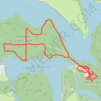
Killykeen Forest Park
Loop hike through Killykeen Forest by the Lough Oughter from Derinish Beg via Killykeen Greenway. #Hiking #Loop #Nature #Forest #Park #Lake
- Distance: 4.6 mi
- Elevation gain: 95 m
- Maximum elevation: 68 m
- Elevation loss: 93 m
- Minimum elevation: 46 m
- Moving time: 1 h 30 m
- Moving speed: 3.1 mph
- Maximum speed: 8.2 mph
- Total time: 1 h 33 m
- Global speed: 3.0 mph
Interactive trail map
Trail profile
- Distance: 4.6 mi
- Elevation gain: 95 m
- Maximum elevation: 68 m
- Elevation loss: 93 m
- Minimum elevation: 46 m
- Moving time: 1 h 30 m
- Moving speed: 3.1 mph
- Maximum speed: 8.2 mph
- Total time: 1 h 33 m
- Global speed: 3.0 mph
About this trail
Name: Killykeen Forest Park trail, distance, elevation, map, profile, GPS track
Coordinates: 54.00448 -7.49225 54.01533 -7.46404