Thank you for supporting this site ❤️
Make a donation
Make a donation
Gear up for your next adventure:
As an Amazon Associate, this site earns from qualifying purchases at no extra cost to you.
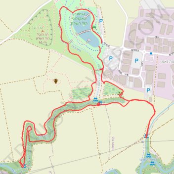
סיור עששיות ליד הפארק האקולוגי בהוד השרון
- Distance: 2.9 mi
- Elevation gain: 16 m
- Maximum elevation: 22 m
- Elevation loss: 15 m
- Minimum elevation: 16 m
- Moving time: 1 h 11 m
- Moving speed: 2.4 mph
- Maximum speed: 4.7 mph
- Total time: 1 h 18 m
- Global speed: 2.2 mph
Interactive trail map
Thank you for supporting this site ❤️
Make a donation
Make a donation
Gear up for your next adventure:
As an Amazon Associate, this site earns from qualifying purchases at no extra cost to you.
Trail profile
- Distance: 2.9 mi
- Elevation gain: 16 m
- Maximum elevation: 22 m
- Elevation loss: 15 m
- Minimum elevation: 16 m
- Moving time: 1 h 11 m
- Moving speed: 2.4 mph
- Maximum speed: 4.7 mph
- Total time: 1 h 18 m
- Global speed: 2.2 mph
Thank you for supporting this site ❤️
Make a donation
Make a donation
Gear up for your next adventure:
As an Amazon Associate, this site earns from qualifying purchases at no extra cost to you.
About this trail
Name: סיור עששיות ליד הפארק האקולוגי בהוד השרון trail, distance, elevation, map, profile, GPS track
Coordinates: 32.12497 34.88682 32.13384 34.89569
Thank you for supporting this site ❤️
Make a donation
Make a donation
Gear up for your next adventure:
As an Amazon Associate, this site earns from qualifying purchases at no extra cost to you.