Make a donation
Gear up for your next adventure:
As an Amazon Associate, this site earns from qualifying purchases at no extra cost to you.
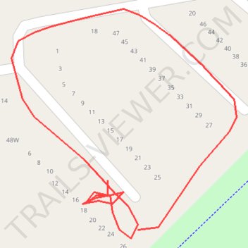
2026-04-12_10-05_Sun
- Distance: 0.2 mi
- Elevation gain: 5 m
- Maximum elevation: 156 m
- Elevation loss: 3 m
- Minimum elevation: 153 m
- Moving time: 2 m 15 s
- Moving speed: 5.7 mph
- Maximum speed: 11.5 mph
- Total time: 10 m 30 s
- Global speed: 1.2 mph
Interactive trail map
Make a donation
Gear up for your next adventure:
As an Amazon Associate, this site earns from qualifying purchases at no extra cost to you.
Trail profile
- Distance: 0.2 mi
- Elevation gain: 5 m
- Maximum elevation: 156 m
- Elevation loss: 3 m
- Minimum elevation: 153 m
- Moving time: 2 m 15 s
- Moving speed: 5.7 mph
- Maximum speed: 11.5 mph
- Total time: 10 m 30 s
- Global speed: 1.2 mph
Make a donation
Gear up for your next adventure:
As an Amazon Associate, this site earns from qualifying purchases at no extra cost to you.
About this trail
Name: 2026-04-12_10-05_Sun trail, distance, elevation, map, profile, GPS track
End: South Morang, Melbourne, City of Whittlesea, Victoria, 3752, Australia (-37.64849 145.07899)
Coordinates: -37.64869 145.07857 -37.64790 145.07955
Make a donation
Gear up for your next adventure:
As an Amazon Associate, this site earns from qualifying purchases at no extra cost to you.
Other hiking, mountain biking, running and outdoor activity trails
Click on a trail to view its statistics, map and profile.
Tallarook - Eildon - Hurstbridge
Australia > Victoria > Tallarook
#Bike
Distance: 173.2 mi • Elevation gain: 4,897 m • Maximum elevation: 868 m
Ashburton to Mernda (cycle)
Australia > Victoria > Melbourne
Distance: 26.2 mi • Elevation gain: 392 m • Maximum elevation: 163 m