19 Dec. 2022 10:10:05 am
- Distance: 2.9 mi
- Elevation gain: 22 m
- Maximum elevation: 38 m
- Elevation loss: 21 m
- Minimum elevation: 23 m
- Moving time: 12 m 59 s
- Moving speed: 13.5 mph
- Maximum speed: 30.7 mph
- Total time: 35 m 23 s
- Global speed: 5.0 mph
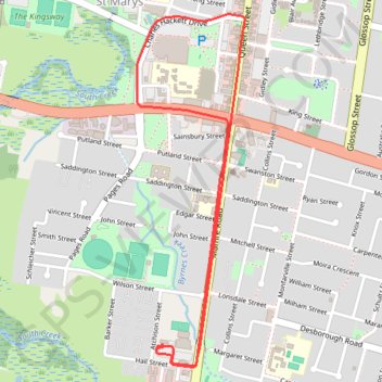
Interactive trail map
Trail profile
- Distance: 2.9 mi
- Elevation gain: 22 m
- Maximum elevation: 38 m
- Elevation loss: 21 m
- Minimum elevation: 23 m
- Moving time: 12 m 59 s
- Moving speed: 13.5 mph
- Maximum speed: 30.7 mph
- Total time: 35 m 23 s
- Global speed: 5.0 mph
About this trail
Name: 19 Dec. 2022 10:10:05 am trail, distance, elevation, map, profile, GPS track
Coordinates: -33.78055 150.76869 -33.76561 150.77418
Other hiking, mountain biking, running and outdoor activity trails
Click on a trail to view its statistics, map and profile.