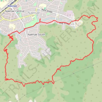
Naenae Hills loop walk
- Distance: 7.7 mi
- Elevation gain: 507 m
- Maximum elevation: 349 m
- Elevation loss: 507 m
- Minimum elevation: 11 m
- Moving time: 2 h 57 m
- Moving speed: 2.6 mph
- Maximum speed: 9.2 mph
- Total time: 3 h 31 m
- Global speed: 2.2 mph
Interactive trail map
Trail profile
- Distance: 7.7 mi
- Elevation gain: 507 m
- Maximum elevation: 349 m
- Elevation loss: 507 m
- Minimum elevation: 11 m
- Moving time: 2 h 57 m
- Moving speed: 2.6 mph
- Maximum speed: 9.2 mph
- Total time: 3 h 31 m
- Global speed: 2.2 mph
About this trail
Name: Naenae Hills loop walk trail, distance, elevation, map, profile, GPS track
Coordinates: -41.22042 174.94313 -41.20121 174.97685