
Henry Hudson Trail
This ride follows the Henry Hudson Trail’s northern Bayshore rail corridor from the Aberdeen–Keyport edge, leaving the busy rail-and-parkway setting for a flat, paved, mostly tree-lined greenway through suburban streets, creeks, wetlands and neighborhood parkland.
From west to east, the route passes Keyport’s inland edge, Union Beach, Natco Lake and Thorns Creek, then continues through Keansburg and North Middletown toward Port Monmouth, Belford and Leonardo, with intermittent glimpses of the Raritan Bay and Sandy Hook Bay landscape beyond the houses and marshes.
The finish near Leonardo and the Atlantic Highlands border brings the ride to the Henry Hudson Trail Activity Center area, where the Bayshore section can continue toward the marina and coastal extension, giving the outing a gentle rail-trail character that blends shaded corridor, tidal waterways and bay-side atmosphere.
#Bike #Nature #Forest #Atlantic #Ocean #Sea #Cycling #Coast #Creek #Wetlands #Greenway
- Distance: 9.7 mi
- Elevation gain: 42 m
- Maximum elevation: 14 m
- Elevation loss: 49 m
- Minimum elevation: 1 m
Interactive trail map
Trail profile
- Distance: 9.7 mi
- Elevation gain: 42 m
- Maximum elevation: 14 m
- Elevation loss: 49 m
- Minimum elevation: 1 m
About this trail
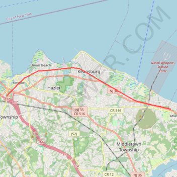
Name: Henry Hudson Trail trail, distance, elevation, map, profile, GPS track
Coordinates: 40.41276 -74.21206 40.44419 -74.04809