Thank you for supporting this site ❤️
Make a donation
Make a donation
Gear up for your next adventure:
As an Amazon Associate, this site earns from qualifying purchases at no extra cost to you.
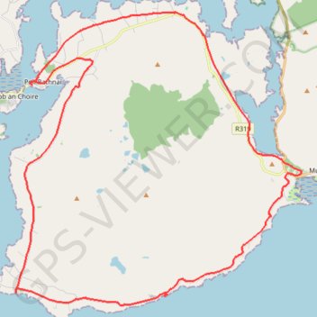
Corraun loop
- Distance: 23.4 mi
- Elevation gain: 346 m
- Maximum elevation: 48 m
- Elevation loss: 348 m
- Minimum elevation: 0 m
- Moving time: 2 h 16 m
- Moving speed: 10.3 mph
- Maximum speed: 21.5 mph
- Total time: 2 h 57 m
- Global speed: 7.9 mph
Interactive trail map
Thank you for supporting this site ❤️
Make a donation
Make a donation
Gear up for your next adventure:
As an Amazon Associate, this site earns from qualifying purchases at no extra cost to you.
Trail profile
- Distance: 23.4 mi
- Elevation gain: 346 m
- Maximum elevation: 48 m
- Elevation loss: 348 m
- Minimum elevation: 0 m
- Moving time: 2 h 16 m
- Moving speed: 10.3 mph
- Maximum speed: 21.5 mph
- Total time: 2 h 57 m
- Global speed: 7.9 mph
Thank you for supporting this site ❤️
Make a donation
Make a donation
Gear up for your next adventure:
As an Amazon Associate, this site earns from qualifying purchases at no extra cost to you.
About this trail
Name: Corraun loop trail, distance, elevation, map, profile, GPS track
Coordinates: 53.86670 -9.92724 53.95483 -9.78144
Thank you for supporting this site ❤️
Make a donation
Make a donation
Gear up for your next adventure:
As an Amazon Associate, this site earns from qualifying purchases at no extra cost to you.
Other hiking, mountain biking, running and outdoor activity trails
Click on a trail to view its statistics, map and profile.
Connemara - Day 2
#Bike
Distance: 46.8 mi • Elevation gain: 797 m • Maximum elevation: 69 m