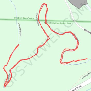
Chamberlain - North Cheyenne Canyon Park
Walked the trail
- Distance: 0.8 mi
- Elevation gain: 55 m
- Maximum elevation: 1,995 m
- Elevation loss: 55 m
- Minimum elevation: 1,950 m
- Moving time: 18 m 13 s
- Moving speed: 2.7 mph
- Maximum speed: 4.4 mph
- Total time: 18 m 13 s
- Global speed: 2.7 mph
Interactive trail map
Trail profile
- Distance: 0.8 mi
- Elevation gain: 55 m
- Maximum elevation: 1,995 m
- Elevation loss: 55 m
- Minimum elevation: 1,950 m
- Moving time: 18 m 13 s
- Moving speed: 2.7 mph
- Maximum speed: 4.4 mph
- Total time: 18 m 13 s
- Global speed: 2.7 mph
About this trail
Name: Chamberlain - North Cheyenne Canyon Park trail, distance, elevation, map, profile, GPS track
Start: Chamberlain, Colorado Springs, El Paso County, Colorado, 80905, United States (38.79162 -104.87040)
End: Chamberlain, Colorado Springs, El Paso County, Colorado, 80905, United States (38.79161 -104.87044)
Coordinates: 38.79102 -104.87264 38.79277 -104.87040
Other hiking, mountain biking, running and outdoor activity trails
Click on a trail to view its statistics, map and profile.
Columbine Trail - North Cheyenne Canyon
United States > Colorado > El Paso County
Distance: 1.6 mi • Elevation gain: 82 m • Maximum elevation: 2,032 m