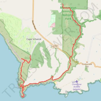
Greens Bush - Cape Schanck loop
- Distance: 11.5 mi
- Elevation gain: 462 m
- Maximum elevation: 150 m
- Elevation loss: 445 m
- Minimum elevation: 0 m
- Moving time: 2 h 33 m
- Moving speed: 4.5 mph
- Maximum speed: 10.3 mph
- Total time: 3 h 37 m
- Global speed: 3.2 mph
Interactive trail map
Trail profile
- Distance: 11.5 mi
- Elevation gain: 462 m
- Maximum elevation: 150 m
- Elevation loss: 445 m
- Minimum elevation: 0 m
- Moving time: 2 h 33 m
- Moving speed: 4.5 mph
- Maximum speed: 10.3 mph
- Total time: 3 h 37 m
- Global speed: 3.2 mph
About this trail
Name: Greens Bush - Cape Schanck loop trail, distance, elevation, map, profile, GPS track
Coordinates: -38.49959 144.88622 -38.43877 144.93638
Other hiking, mountain biking, running and outdoor activity trails
Click on a trail to view its statistics, map and profile.
Greens Bush, Mornington Peninsula National Park and Cape schanck loop
Australia > Victoria > Melbourne > Main Ridge
Distance: 19.2 mi • Elevation gain: 632 m • Maximum elevation: 178 m
Cape Schanck - Mornington Peninsula
Australia > Victoria > Melbourne > Cape Schanck
Distance: 4.9 mi • Elevation gain: 324 m • Maximum elevation: 81 m
St Andrews Beach, Boag rocks, Gunnamatta beach, Cape Schanck walk
Australia > Victoria > Melbourne
Distance: 7.9 mi • Elevation gain: 263 m • Maximum elevation: 122 m