New
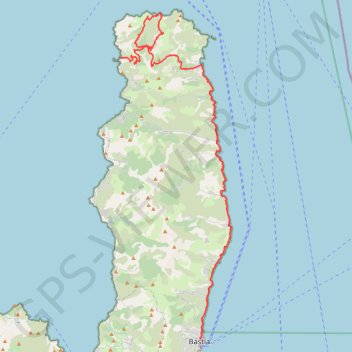
- Distance: 43.3 mi
- Elevation gain: 1,803 m
- Maximum elevation: 364 m
- Elevation loss: 1,802 m
- Minimum elevation: -2 m
Interactive trail map
Trail profile
- Distance: 43.3 mi
- Elevation gain: 1,803 m
- Maximum elevation: 364 m
- Elevation loss: 1,802 m
- Minimum elevation: -2 m
About this trail
Name: New trail, distance, elevation, map, profile, GPS track
Coordinates: 42.70178 9.35000 43.00768 9.49227
Other hiking, mountain biking, running and outdoor activity trails
Click on a trail to view its statistics, map and profile.
1 LUCENA - MONTPELLIER
Distance: 1,842.0 mi • Elevation gain: 29,500 m • Maximum elevation: 1,048 m
New
France > Corsica > Haute-Corse > Bastia
Distance: 34.1 mi • Elevation gain: 1,385 m • Maximum elevation: 364 m
New
France > Corsica > Haute-Corse > Port de Centuri
Distance: 36.4 mi • Elevation gain: 2,161 m • Maximum elevation: 203 m
New
France > Corsica > Haute-Corse > Port de Centuri
Distance: 39.1 mi • Elevation gain: 2,375 m • Maximum elevation: 240 m