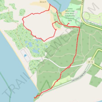
Walk - Sandbanks Provincial Park
Canada, ON, Prince Edward
- Distance: 4.1 mi
- Elevation gain: 62 m
- Maximum elevation: 94 m
- Elevation loss: 62 m
- Minimum elevation: 74 m
- Moving time: 1 h 49 m
- Moving speed: 2.2 mph
- Maximum speed: 3.3 mph
- Total time: 2 h 24 m
- Global speed: 1.7 mph
Interactive trail map
Trail profile
- Distance: 4.1 mi
- Elevation gain: 62 m
- Maximum elevation: 94 m
- Elevation loss: 62 m
- Minimum elevation: 74 m
- Moving time: 1 h 49 m
- Moving speed: 2.2 mph
- Maximum speed: 3.3 mph
- Total time: 2 h 24 m
- Global speed: 1.7 mph
About this trail
Name: Walk - Sandbanks Provincial Park trail, distance, elevation, map, profile, GPS track
Start: Sandbanks Dunes Trail, Prince Edward County, Central Ontario, Ontario, Canada (43.90843 -77.27253)
End: Sandbanks Dunes Trail, Prince Edward County, Central Ontario, Ontario, Canada (43.90846 -77.27254)
Coordinates: 43.89683 -77.28266 43.91147 -77.27026
Other hiking, mountain biking, running and outdoor activity trails
Click on a trail to view its statistics, map and profile.