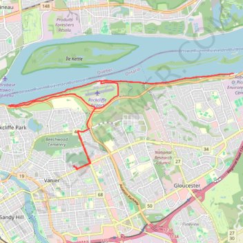
Ottawa River Pathway
- Distance: 13.4 mi
- Elevation gain: 130 m
- Maximum elevation: 80 m
- Elevation loss: 132 m
- Minimum elevation: 41 m
- Moving time: 1 h 19 m
- Moving speed: 10.2 mph
- Maximum speed: 20.8 mph
- Total time: 23 h 3 m
- Global speed: 0.6 mph
Interactive trail map
Trail profile
- Distance: 13.4 mi
- Elevation gain: 130 m
- Maximum elevation: 80 m
- Elevation loss: 132 m
- Minimum elevation: 41 m
- Moving time: 1 h 19 m
- Moving speed: 10.2 mph
- Maximum speed: 20.8 mph
- Total time: 23 h 3 m
- Global speed: 0.6 mph
About this trail
Name: Ottawa River Pathway trail, distance, elevation, map, profile, GPS track
Start: Montréal Road, Rideau-Vanier, Ottawa, Eastern Ontario, Ontario, K1L 6B3, Canada (45.44004 -75.65241)
Coordinates: 45.43931 -75.67862 45.46581 -75.59052
Other hiking, mountain biking, running and outdoor activity trails
Click on a trail to view its statistics, map and profile.
Ottawa - Grenville-sur-la-Rouge
Canada > Ontario > (Old) Ottawa
Ottawa River. #Bike #Ottawa #GrenvilleSurLaRouge
Distance: 58.1 mi • Elevation gain: 330 m • Maximum elevation: 73 m