Thank you for supporting this site ❤️
Make a donation
Make a donation
Gear up for your next adventure:
As an Amazon Associate, this site earns from qualifying purchases at no extra cost to you.
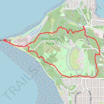
Discovery Park loop hike via West Point Light
- Distance: 4.4 mi
- Elevation gain: 173 m
- Maximum elevation: 103 m
- Elevation loss: 173 m
- Minimum elevation: 0 m
- Moving time: 2 h 55 m
- Moving speed: 1.5 mph
- Maximum speed: 22.7 mph
- Total time: 3 h 36 m
- Global speed: 1.2 mph
Interactive trail map
Thank you for supporting this site ❤️
Make a donation
Make a donation
Gear up for your next adventure:
As an Amazon Associate, this site earns from qualifying purchases at no extra cost to you.
Trail profile
- Distance: 4.4 mi
- Elevation gain: 173 m
- Maximum elevation: 103 m
- Elevation loss: 173 m
- Minimum elevation: 0 m
- Moving time: 2 h 55 m
- Moving speed: 1.5 mph
- Maximum speed: 22.7 mph
- Total time: 3 h 36 m
- Global speed: 1.2 mph
Thank you for supporting this site ❤️
Make a donation
Make a donation
Gear up for your next adventure:
As an Amazon Associate, this site earns from qualifying purchases at no extra cost to you.
About this trail
Name: Discovery Park loop hike via West Point Light trail, distance, elevation, map, profile, GPS track
Coordinates: 47.65424 -122.43604 47.66488 -122.40668
Thank you for supporting this site ❤️
Make a donation
Make a donation
Gear up for your next adventure:
As an Amazon Associate, this site earns from qualifying purchases at no extra cost to you.
Other hiking, mountain biking, running and outdoor activity trails
Click on a trail to view its statistics, map and profile.
Discovery Park trails
United States > Washington > King County > Seattle
Distance: 10.1 mi • Elevation gain: 295 m • Maximum elevation: 109 m