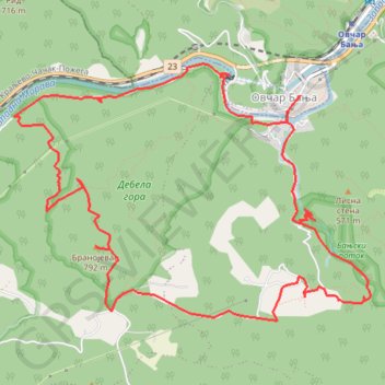
Debela gora: Banjski potok, Branojevac, pećina Kađenica
- Distance: 7.8 mi
- Elevation gain: 726 m
- Maximum elevation: 774 m
- Elevation loss: 726 m
- Minimum elevation: 280 m
- Moving time: 3 h 59 m
- Moving speed: 2.0 mph
- Maximum speed: 3.3 mph
- Total time: 4 h 30 m
- Global speed: 1.7 mph
Interactive trail map
Trail profile
- Distance: 7.8 mi
- Elevation gain: 726 m
- Maximum elevation: 774 m
- Elevation loss: 726 m
- Minimum elevation: 280 m
- Moving time: 3 h 59 m
- Moving speed: 2.0 mph
- Maximum speed: 3.3 mph
- Total time: 4 h 30 m
- Global speed: 1.7 mph
About this trail
Name: Debela gora: Banjski potok, Branojevac, pećina Kađenica trail, distance, elevation, map, profile, GPS track
Coordinates: 43.88157 20.15829 43.90047 20.19463
Other hiking, mountain biking, running and outdoor activity trails
Click on a trail to view its statistics, map and profile.
Debela gora: Banjski potok, Branojevac, pećina Kađenica
Serbia > Central Serbia > Moravica Administrative District > Ovcar Banja
Distance: 8.0 mi • Elevation gain: 695 m • Maximum elevation: 774 m
2022_Yu
Slovenia > Ajdovščina > Žapuže
Distance: 1,526.9 mi • Elevation gain: 32,048 m • Maximum elevation: 1,950 m
OVČAR: Dom - Ratkova staza - VRH OVČARA (985 m) - Sretenje -...
Serbia > Central Serbia > Moravica Administrative District > Ovcar Banja
Distance: 7.2 mi • Elevation gain: 886 m • Maximum elevation: 968 m